Data Products and Services
Geological and geophysical data comprise analytical data and data products which are derived from seabed sediment samples, boreholes, borehole samples, geophysical surveys (seismic, gravity, magnetic) of the seabed and sub-seabed, cone penetration tests, and sides can sonar surveys. The data, products and services being delivered by the Geo-Seas project can be used by a number of sectors including: environmental research and monitoring; academic research; government; national and regional agencies; dredging; marine hydrocarbons; beach nourishment; land reclamation; sustainable energy; civil engineering (pipelines, offshore construction, aggregates); communications (submarine cables); shipping; fisheries; and tourism.
As part of Geo-Seas a number of new data products and services have been developed with input from the user consultation that was conducted early in the project. This included an online user survey, conducted from mid December 2009 to June 2010 to learn more about user requirements, followed up by an in-depth user consultation conducted through one-to-one interviews, either in-person or by telephone, and small focus group meetings.
Geo-Seas has developed the following new data products and viewing services, also in crossfertilisation with the on-going SeaDataNet II, One-Geology Europe, EUROFLEETS, EMODNet Geology and EMODNet Hydrography projects:
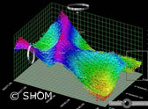
- Digital Terrain Model and 3D viewing software
- Digital Terrain Model and 2D viewing service
- Borehole Viewer software
- Standardization in seabed habitat mapping
In addition, a pilot was undertaken for seismic viewing services. However this pilot is discontinued.
Furthermore, OGC standards have been adopted for the distribution and viewing services. These comprise Web Map Services (WMS) and Web Feature Services (WFS), supporting the quick viewing and visualization of data sets and data products.